


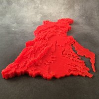

SummaryContour map of the Chesapeake Bay Watershed made for a summer STEM camp to illustrate the effect of terrain on the flow of water to the Chesapeake Bay. Details about the construction of this map can be found at http://designmaketeach.com/2015/07/02/design-challenge-chesapeake-bay-watershed/ . I need help with developing a simpler technique for creating similar maps for use as educational manipulates. If you can help, please leave a comment or contact me on Twitter @DesignMakeTeach.com This thing was made with Tinkercad. Edit it online https://www.tinkercad.com/things/aq5nCOnZCEA I have also created a laser and paper cut version of the map using the same base set of svg files but have not collected them for publishing yet. There is an error in the file as I was experimented with simplifying the contour lines.
Loading prints...
Chesapeake Bay Watershed Contour Map
Creative Commons Attribution-ShareAlike
You can distribute, remix, adapt, and build upon the material in any medium or format, as long as attribution is given and your contributions are under the same license.
 Licensed under CC BY-SA
Files Included
1 downloadable file:
Downloaded: 46 times
Loading comments...