
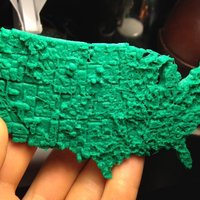

SummaryFor my long paper in my computational economics class I decided to do economic data visualization using my 3d printer. I took an unemployment map of the US by county in 2009 and turned it into a 3d object with the unemployment level displayed by relative height. It also functions as an accurate pocket map of the US.InstructionsPrinted with 40% infill. PLA/ABS works. The STL scales decently so feel free to print in any dimensions, I would suggest calibrating your E-retraction length because it will have strands if it isn't perfect.
It would be really cool if someone else printed this before I turn in my paper on Friday, I would totally put that in the paper!
Javascript I used can be found here: http://www.thingiverse.com/thing:15276
Economic Data was taken from the Bureau of Labor Statistics and the image can be found here: http://flowingdata.com/wp-content/uploads/2012/01/Unemployment-choropleth-425x278.png
Loading prints...
Pocket Unemployment Map of the United States
4
likes
1
collection
Tags:
Creative Commons Attribution-ShareAlike
You can distribute, remix, adapt, and build upon the material in any medium or format, as long as attribution is given and your contributions are under the same license.
 Licensed under CC BY-SA
Files Included
1 downloadable file:
Free download - login required
Downloaded: 93 times
Downloaded: 93 times


Loading comments...